Cadet Designs Off-Road Mapping System

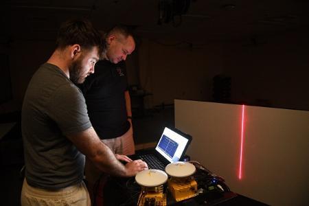
Bruce Hay ’25 and Maj. Craig Altmann work with the off-road laser measurement mapping system. –VMI Photo by Kelly Nye.
LEXINGTON, Va., Aug. 2, 2024—According to Precedence Research, the off-road vehicle market in the United States was valued at $12.63 billion in 2023, and is anticipated to reach around $19.09 billion by 2033. Clearly many people enjoy the fun and adventure that off-roading provides. Often though, off-roading can turn dangerous when hazards on the trail are unseen and unexpected, and what appears to be a small puddle, may actually be a large crater which can compromise the safety of the vehicle and its occupants. Bruce Hay ’25, a Virginia Military Institute cadet majoring in mechanical engineering with a concentration in aerospace engineering and an applied mathematics minor, completed his 10-week Summer Undergraduate Research Institute (SURI) project by designing an off-road laser measurement mapping system to forewarn drivers of trail conditions and help prevent dangerous mishaps.
Hay first became interested in pursuing the summer project while enrolled in a spring semester class in machine dynamics, taught by Maj. Craig Altmann, assistant professor in the Department of Mechanical Engineering (ME). Altmann mentioned that he had received funding and purchased equipment necessary to build a precision laser measurement tool including, a scanning laser, a global positioning system (GPS), and an inertial measurement unit (IMU), that measures and reports acceleration, orientation, and gravitational forces. This intrigued Hay, especially since he had recently taken a class in mechatronics—which combines mechanical, electrical, and computer engineering—a requirement for any cadet involved in building the measurement tool. According to Hay, accurate measurement of off-road surfaces can provide more accurate input to vehicles, and provide information to road maintenance crews to help them determine when road maintenance should be performed.
Initially, Hay was tasked with having to learn C #, a computer programming language essential to designing his mapping system. According to Altmann, the difficulty level in learning the program, is the equivalent of learning a new language. “It was like him having to learn Spanish in just six weeks,” he said. Hay struggled at first, but with help from his professors, brother rats, and outside resources, he was able to master the new program language. MATLAB, a high-level programming language designed for engineers, is one Hay already had extensive experience using. Both MATLAB with C # were used in conjunction by Hay in the design of his project.
“The C # code sends a signal to a timer on a circuit board, which starts a repeating frequency to the laser that we control. We can speed up the laser frequency, or slow it down. By pressing a key on the computer keyboard, we are able to turn on the laser and the GPS, and all the information starts to get logged and uploaded onto the computer. We then take all that information and enter it into MATLAB to bring all the data together to examine coordinates on the road,” explained Hay.
To test the mapping system, Hay and Altmann set up a small base station within their testing area to hone in a signal with satellite and the closest radio tower, which is 40 miles away, in Roanoke. The laser is mounted on the hitch of a truck, and as the truck is driven, data is collected. “We tested out the GPS on the truck while driving around the VMI parking lot. The data came out really well. We haven’t fully tested the entire system together, but the independent parts fully work. We can take full measurements from the laser, and take full data from the GPS,” stated Hay.
“Hay was very successful this summer completing his part of this research, which is the electrical and programming side of it, not the mechanical side. As soon as the frame is built and the laser, GPS, and IMU are mounted to it, we will be able to measure terrain surfaces with ease,” stated Altmann, who will be continuing the project in the fall as part of his research.
Hay, from Whiting, New Jersey, graduated from Donavon Catholic High School in nearby Toms River. He is the son of Bruce and Victoria Hay. Upon graduating, he hopes to work in the field of aerospace engineering.
Marianne Hause
Communications & Marketing
VIRGINIA MILITARY INSTITUTE
.svg)
.png)